Taking hydromorphology assessments for a test drive

Taking hydromorphology assessments for a test drive
Natural conditions vary greatly across the Danube River Basin, so naturally assessment standards must be tailored for each country. Sharing experiences on the methodologies used can help countries develop the right approach about for them.

Collecting information on hydromorphological pressures is needed for a range of WFD requirements, including water body delineation, identification of heavily modified or artificial water bodies, pressure and impact analysis, setting monitoring standards, developing biological assessment methods and developing a programme of measures.
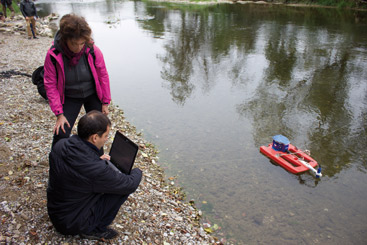
© Agency for the Water District of the River Sava, Bosnia and Herzegovina
Good hydromorphology is essential to meet the requirements of the EU Water Framework Directive (WFD), which requires that waters must provide good conditions, such as migration routes and sustainable habitats, for natural species to live in good health.
“The main challenge is to establish the way to regularly assess hydromorphological changes and their link to aquatic species and habitats,” says Dragana Ninkovic, Lead Research Engineer at the JAROSLAV CERNI Institute for the development of Water Resources in Belgrade, Serbia. “Since there’s no exact (mathematical, numerical, etc.) method, it is a real challenge to balance between strict and mild rating which both can cause wrong assessment and thus inappropriate measures.”
In a survey prepared for the ICPDR Hydromorphology Workshop held this September in Vienna, only half the Danube countries responding had developed an assessment methodology for all the WFD hydromorphology quality elements. To help countries develop one, the workshop presented several different approaches and took workshop participants out in the field to the Pielach River in Lower Austria to test drive four of the methodologies.
The field work allowed participants to see the advantages and disadvantages of each approach first hand, as well as the opportunity to discuss the level of accuracy needed for specific conditions in each country. “Although all approaches are country-specific,” says Ninkovic, “Serbia can use experience gained from each of them.”
The experience also proved valuable to countries which had already developed a methodology. “It was very interesting to get some criticism which made sense – things that I hadn’t really thought of before,” says Helena Mühlmann at the Austrian Federal Ministry of Agriculture, Forestry, Environment and Water Management. A background paper on all the approaches presented will be distributed next year.
Learning from the field
The first method tested was a pragmatic approach used in Austria. This methodology divides the catchment into 500m stretches, assessing each stretch using two parameters: bank dynamics and river bed dynamics. Although this provides only a rough classification of the river, it is possible to cover the whole river net of the country using this approach.
The next was an approach used in Slovakia taking precise measurements of eight key indicators: river planform, habitat diversity, flow regime and dynamics, sediment and fish continuity, local channel morphology, later connectivity, riparian zone and floodplain. An index calculated for the individual river stretch is then applied to the whole territory. While time consuming, this method provides very detailed information on the spot, which is vital for planning a programme of measures.
Strict or flexible. A method used in Hungary assesses nine parameters: channel section, extent of artificial material, erosion or deposition, impact of water abstraction, impact of water discharges, longitudinal continuity, bank structures and modifications, adjacent land-use and floodplain connectivity. This methodology was the strictest of the approaches presented, as the worst result of all of the parameters is taken for the entire assessment.
The European Committee for Standardisation method assesses ten parameters: channel geometry, substrates, channel vegetation and organic debris, erosion and deposition character, flow, longitudinal continuity, bank structure and modifications, vegetation on adjacent land and river and floodplain connectivity. This shows how the status of a particular parameter affects the whole water body, but does not provide specific information about the location of pressures.


