Saving a sacred river

Saving a sacred river
An Indo-German cooperation project is bringing experts from the Danube and the Ganga rivers together to share knowledge and experiences on protecting these unique rivers to help river basins achieve their shared goals.

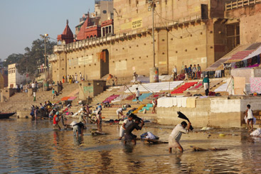
The lack of sanitation, sewage networks and treatment contributes roughly 75% of the liquid waste the river has to cope with.
© Bark
The waters of the Ganga River (commonly known as the Ganges) rise in the Himalayas, from some of the highest peaks on Earth. What’s more, the Ganga has significant religious importance, and is a lifeline to all who live along its banks. However the Ganga Basin is one of the most intensely inhabited regions, home to 450 million people, with the result that the river’s water over much of its course is highly polluted.
The National Ganga River Basin Authority (NGRBA) was established to provide more focused attention on cleaning the river. The NGRBA’s objectives are to decrease pollution effectively and conserve the Ganga River by adopting a river basin approach to promote coordinated planning and management. The NGRBA also aims to ensure water quality and environmentally sustainable development.
The National Mission for Clean Ganga (NMCG) – under the Ministry for Water Resources, River Development and Ganga Rejuvenation – implements the mandate of the NGRBA at the national level. State Level Programme Management Groups from the five states located along the main stream of the Ganga River (Uttar Pradesh, Uttarakhand, Bihar, Jharkhand and West Bengal – with a total population of 400 million people) are responsible for the more detailed project management – such as planning or selection – and for achieving monitoring and evaluation results.
Further degradation of the river. Despite all efforts, however, the situation of the Ganga River is still critical. In general, the stresses on the river have not been reduced, and in some stretches the conditions of the river have even deteriorated.
Wastewater generation has increased and even partly exceeded new treatment capacities thereby keeping the share of treated urban wastewater below 50%. The main source of wastewater is municipal wastewater from the people living in the river basin. The lack of sanitation, sewage networks and treatment contributes roughly 75% of the liquid waste the rivers have to cope with. Another source of pollution stems from industry, mostly small scale industries, such as pulp & paper and tanneries. Solid waste is another harmful source of pollution, ranging from non-degradable plastic to human bodies, clogging the few existent sewage networks and the riverbed. Additionally, non-point sources of pollution, such as runoffs from agriculture in the form of fertilisers, pesticides, livestock and liquid waste, among others.
Other reasons for the river’s degradation are issues of quantity. A tremendous amount of water is being abstracted from the river (according to the World Bank almost 90%), mainly for agricultural use. In addition, the increasing construction of hydropower plants and their operations are changing the hydromorphology and flow of the river.
Fortunately, however, Ganga rejuvenation efforts have gained momentum with the establishment of the NamamiGange (“Clean Ganga”) umbrella programme by Prime Minister Narendra Modi, elected in spring 2014. With efforts to foster inter-sectoral cooperation to manage the river basin, sharing experiences with other river basin commissions (such as for the Rhine, Elbe and Danube) has been beneficial.

© Bark
Learning from the ICPDR. The preparation for the Second Danube River Basin Management Plan – to be adopted in December – provided an excellent opportunity for the NMCG to gain insight into how the ICPDR steers the complex task of coordinating 14 countries to manage a large river basin. There are lessons to learn from this challenge for the coordination of the Federal States and the Central Government in India within the Ganga River Basin.
A representative and expert from NMCG went to Vienna for 10 days in September 2015 and was told about the ICPDR and its history, to the Danube River Basin and the ICPDR contracting parties. He also learned about the ICPDR's legal framework, objectives and tools, as operational and surveillance monitoring, status analysis, joint programme of measures, and methods of public consultation and participation. The visit included trips to the Slovak Hydrometeorological Institute in Bratislava, the Waste Water Treatment Plant in Vienna, the Ministry of Water, Environment Agriculture and Forestry in Vienna, and the Schloss Orth National Park.
The objective of this ‘on-the-job-training’ visit was to learn about the key challenges of river basin planning, assessment and management in the Danube River Basin. Of particular interest were issues of water quality, river hydromorphology and the biological and technical interaction of surface and groundwater, cross-sectoral perspectives, impacts generated by other sectors like hydropower, inland navigation and agriculture, which – in relation to ecosystem health – have a significant influence on the river. Other topics addressed during the visit weremonitoring, including biological monitoring, data assessment and management, GIS, governance, stakeholder participation and communication. The visit was organised and financed through the Indo-German cooperation project ‘Advice and knowledge exchange on river basin management’.
Lessons from the Danube. Learning more about the EU Water Framework Directive and the Floods Directive and how they form the core basis of ICPDR was extremely useful. In addition, the ICPDR’s monitoring activities are fairly refined and the GIS database is quite strong and hence the results can be better visualised and presented than by NMCG.
Perhaps one of the biggest payoffs from the experience is the ICPDR’s largest activity. The Joint Danube Survey, the biggest river expedition in the world, which has been carried out every six years, is a useful exercise and provides valuable information on the status of the Danube and the results of activities undertaken. Thanks to the visit to the ICDPR, there are intentions in India to try to stage a survey of the Ganga River to ascertain the status of Ganga every six years along the lines of the Joint Danube Survey.
The Ganga River at a glance
Length: 2,525 km
Source: Gaumukh (Gangotri Glacier)
Major tributaries: Batwa, Chambal, Damodar, Gandak, Ganga, Ghagra, Gomti, Hindon, Kali, Khan, Kosi, Kshipra, Ramganga and Yamuna rivers
Basin size: 1,080,000km2
Drainage area: 861,404km2
Population in the basin: 450 million
For more about the Ganga River and the Ganga River Basin Authority, please visit:
www.moef.nic.in/sites/default/files/ngrba/index.html.


