Danube Watch 3 2010 -Extreme floods in the Danube Basin

Extreme floods in the Danube Basin
Floods are natural phenomena, which have helped to shape natural landscapes, habitats and ecosystems in floodplains, wetlands and other lowlands. Floods can, however, turn into disasters causing widespread damage, health problems and casualties.

The cumulative impact of the floods arriving from the upper Danube together with the Tisza, Sava and Velika Morava tributaries was long standing peaks above the flood alert levels along river reaches downstream of the Iron Gate. Flood crests recorded on the lower Danube from Braila to the Delta brought about by tributaries from the eastern slopes of the Carpathians exceeded all major floods since 1970.
According to climatic data, the 2009-2010 hydrological year (measured from November to November) produced the largest amount of precipitation ever observed inmany parts of the Danube region. The layer of snow and rain along the central Danube exceeded the multiannual average by 1.5 to 2.0 times, a maximum never observed since systematic instrumental weather observations have been available. The ‘wet spill’ started in September 2009, and clouds carried more water than usual in most parts of the region (with the exception of the month March and over some catchments in April).
Corresponding to large amount of snowmelt and rain, excess water or water-table-related flooding occurred in spring months throughout the lowlands. The inundated area was measured in hundreds of thousands of hectares and agricultural production of winter wheat and other crops suffered substantially leading to yields well below the average – if not completely devastating cultivated cultures. Saturated soil in hills and mountains created preconditions for riverine and flash floods.
Unrelenting rains. Intense rainfall and floods occurred in December 2009, and a ‘Christmas flood’ caused alerts on the Hron stream and endangered the city of Banska Bystrica in Central Slovakia. Extreme weather and flood events continued until late September/October 2010.
Dangerous hydrometeorological phenomena were most intense from May to July. Flash floods occurred from late April all through the summer months.
The influx of wet air masses on the Danube Basin was most intense during May. The monthly layer of precipitation exceeded seasonal values and moreover most of the rainfall arrived within a short period with atmospheric low pressure on 15-18 May. Storms and heavy rains leaded to flash floods and inundation, and record breaking strong winds removed or destroyed the roofs of hundreds of family homes in eastern Croatia and the Trans-Danubian part of Hungary. Heavy rainfall affected central and northern regions of the Carpathian Basin from the Drava lowland to the Beskied Mountains and catchments of Slovak tributaries entering the Danube and Tisza. Similar extreme events followed within a surprisingly short period in late May and on the first days of June when the Bavarian Danube, Inn and catchments of Upper Austria also had torrential rain.

Unprecedented high waters. In addition to wide spread flash floods from Salzburg in Austria to the Trans-Carpathian region of Ukraine, major floods propagated along larger streams and the upper and middle currents of the Danube. Hundreds of millimetres of rain at the headwaters of the Morava, Vistula and Oder rivers generated a high flood with a 50-year return period downstream of the tributary Thaya/Dye on the Morava/March, requiring intense flood defence activities along the Austrian– Slovak border.
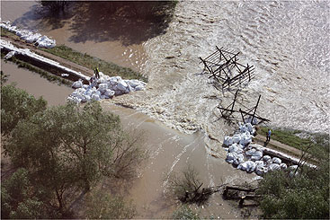
Floods on the tributaries resulted in a significant Danube flood wave upstream of Budapest, equal to the third largest of the last century and causing serious transport problems within the city. The Vienna–Budapest railway line was also at risk while the motorway M1 was cut off by flash-flood-induced damage for a couple of days. The lower Hernád Valley was mostly saved by the construction of a temporary 40-km dike. Water levels reached the historical maximum on the Tisza River at Tiszapalkonya and the recently completed emergency reservoir of Tiszaroff was opened, reducing the flood peak by 15-20 cm and easing the flood protection load on the city of Szolnok.
Several large waves passed the left bank tributaries of the Tisza River and flood alerts were frequent on Transylvanian rivers, however no extreme floods occurred on medium and large streams. Heavy rains at the end of June and early July caused exceptional floods on the Siret, Prut and Jijia rivers. Discharges of the usually peaceful Prut exceeded 2300 m3/s or more than those of the Danube at Budapest under normal flow conditions.
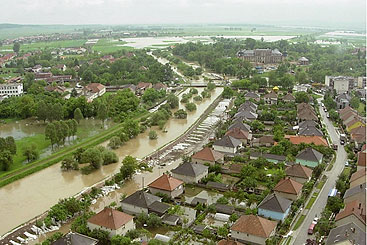
Taking stock of the damage. Massive floods impacted houses and infrastructure, and tens of thousands of hectares of arable land have been affected. The damage to cereal crops has led to further economic losses. Some 198,000 hectares were affected in Hungary, while in Romania 110,000 hectares of agricultural land were inundated by water and an estimate for Romania indicates that overall losses by summer floods will be bigger than 0.6% of the gross domestic product. Around 1000 homes were destroyed or damaged by floods in Hungary. Including infrastructure losses, the costs of the floods is more than 100 million Euros.

The most widespread damage was caused by flash floods; including infrastructure losses, the costs of the floods is more than 100 million Euros.
The most widespread damage was caused by flash floods. Numerous cases were recorded in Slovenia and Croatia and in the upper part of the Velika Morava catchment in Serbia and large parts of Bosnia and Bulgaria. More than 900 localities in Slovakia and 510 in Hungary suffered. In Romania 3000 houses, 4130 km of national and regional roads as well as 700 bridges were damaged. Major floods on the Sava required extensive efforts to protect the region around Zagreb. Flash floods induced by torrential rain resulted in casualties on creeks entering the Mures and Târnava. Other Romanian counties east of the Carpathians suffered even more, leading to more than a dozen casualties in the region totalling 24 in the country. At least 50 flood victims were claimed within the entire Danube Basin.
Understanding flood risks. The lessons learnt showed that while reliable forecasting of flash floods is rather complicated, regular maintenance of river channels ensuring unhindered flow during extreme hydrological conditions can remarkably decrease the risk of flood damages.

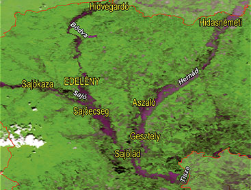
The extreme character of the events was manifested on streams of the Slana/Sajó River network together with the Hornád/Hernád and Bodva rivers where two or three subsequent flood peaks exceeded the historical maximum of 1974.
Emergency services and agencies responsible for the management of water infrastructure were put on high alert during summer months. National efforts were sufficient to cope with rising emergencies; however, the economic losses were vast. Studies on the impact of climate change show it is very likely that there will be massive floods or flash floods in the future, so we must be prepared to cope with them. Therefore the preparation of flood risk maps by 2013 and flood risk management plans by 2015, in accordance with EU legislation, are important steps to living with the flood risks and addressing them with appropriately targeted measures.


