Danube Watch 3/2018 - The Joint Danube Survey

The Joint Danube Survey (JDS) is an ICPDR initiative to help Danube governments implement the Danube River Protection Convention of 1994. It is also designed to help countries meet the requirements of the EU Water Framework Directive (WFD) to ensure that rivers and lakes achieve ‘good chemical and ecological status’.
 T he findings of the three JDS surveys carried out so far have allowed governments to make and implement high-level decisions regarding environmental measures throughout the basin. The key objectives of the three expeditions that have already taken place were:
- to collect data on parameters not analysed during standard ICPDR monitoring
- to collect information about the water and its organisms from single sources along the length of river so that data is readily comparable between countries
- to raise awareness of the quality of the Danube waters and the efforts required to protect and restore them to fill the gaps in WFD implementation.
JDS1
The first Joint Danube Survey (JDS1) was carried out by the ICPDR in 2001 and was the most homogenous analysis of water quality and the ecological status of the Danube River ever conducted. Over 140 chemical and biological parameters were analysed and over 40,000 laboratory results were generated.
Tests revealed that organic pollution on certain stretches of the river ranged from moderate to critical, with many sidearms and tributaries being more polluted than the main stream. In certain stretches no macro-invertebrates were found at all – a clear indication of even higher organic or toxic pollution.
Other tests carried out during JDS1 revealed particularly high levels of nutrient pollution in the Hungarian section of the river downstream from Budapest. Insufficiently treated sewage and contamination from farmland and pastures (manure) were also found to be a problem in this region.
Specific heavy metal pollution hot-spots were detected in the Rusenski Lom, the Iskar and the Timok tributaries in Bulgaria. Pollution from navigation, especially oil pollution, was also found, with high values for petroleum hydrocarbons in sediments and suspended solids being found in stretches of the Middle Danube.
From 23 pesticides under investigation only atrazine and desethylatrazine were found in the Danube. However, significant concentrations of harmful chemical pollutants listed in the WFD List of Priority Substances, were found in bottom sediments as well as in suspended solids.
JDS2
The second survey was launched in mid-August, 2007 and saw 96 sites along the Danube River and 28 on its major tributaries sampled by the three JDS2 boats. JDS2 was the world's biggest ever river research expedition at the time and, as in 2001, the main objective was to produce highly comparable and reliable information on water quality and pollution. After the expedition had ended, scientists throughout Europe analysed water samples, sediment, plants, fish and other aquatic life. This led to a ‘Final Scientific Report’ and a hands-on public document entitled ‘the Joint Danube Survey 2: Research Expedition and Conclusions’. The final results showed that the Danube and its tributaries were becoming cleaner, but measures to reduce particular pressures on the river and its waters were still needed.
JDS3
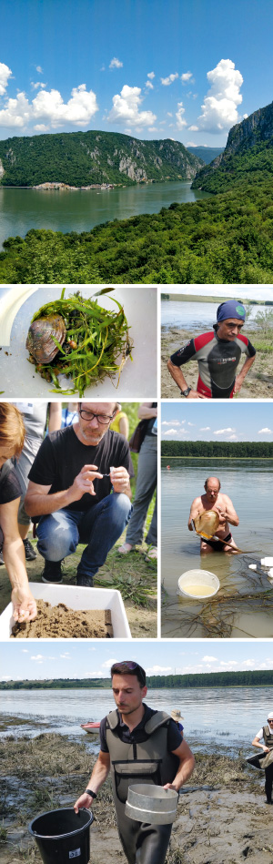
The third survey took place in 2013 and saw the JDS3 ships once again travel 2,375 km downstream, through ten countries, from the Black Forest to the Black Sea. An international Core Team of 20 scientists was responsible for sampling, sample processing, on-board analyses and all other survey activities, with leading laboratories across Europe carrying out biological and chemical analyses.
77% of the sites sampled in 2013 were classified as having good or high ecological status, especially in most of the Upper and Lower reaches of the Danube. Moderate status was mostly recorded in the Middle Danube.
JDS3 reconfirmed that Danube plants and animals show a high degree of biodiversity. This was especially so with fish, with over 139,000 individual fish and 67 species sampled. Nevertheless, due to pressures, such as hydropower, poaching and fishing, about 50% to 90% of the sites tested did not meet WFD ecological requirements for fish. Moreover, invasive alien species continue to have a constant impact on native wildlife, such as alien fish depleting the habitats of native Danube fish.
Once again, the survey provided the largest volume of knowledge about the Danube River Basin ever collected through a single scientific exercise, and once again results confirmed that the waters of the Danube River Basin are progressively becoming healthier and safer for all.
JDS4 – Discovering the Danube!
One of the most comprehensive investigative surface-water monitoring projects undertaken anywhere in the world is scheduled to start this summer.
The key objective of this fourth survey will be to gather vital data information on carefully selected water quality elements at sampling sites in 13 countries across the whole of the length of the Danube River and its major tributaries. JDS4 will harmonise water monitoring practices throughout the Danube countries in accordance with the WFD, thereby committing member states to achieving good water status.
The outcomes of the JDS4 should cover the information gaps deemed necessary for the 2021 update of the Danube River Basin Management Plan. The general added values of JDS4 are as follows:
- an independent basin-wide platform for improving national surface water monitoring practices
- practical joint testing and comparison of national methodologies for biological and hydromorphological quality elements leading to their future harmonisation
- an interactive platform for hands-on training for the sampling and assessment of biological quality elements
- a homogenous source of data for a number of quality elements (especially for emerging substances) for the whole of the Danube River Basin with knowledge transfer available to non-member states.
In addition, there will be a special monitoring team tasked with conducting ad-hoc and less conventional technical tests. Three particularly interesting aspects that require special monitoring include:
- effect-based methods/non-target screening (chemistry): previous surveys have been excellent examples of using effect-based analysis in combination with target chemical analysis to investigate overall contamination
- environmental DNA (eDNA) testing, which is a method to detect DNA that is released from an organism into the environment (in this case, the Danube)
- Microplastics: results from studies on European rivers show that plastics are ubiquitous in freshwater systems. As such data has not yet been gathered for the Danube, it is expected that JDS4 could produce an information baseline on the occurrence of plastic particles for the whole Danube.
The past three Joint Danube Surveys have been based on the principle that a Core Team of leading experts carried out all sampling, including the analysis of all biological, microbiological and hydromorphological samples, while the national experts joined the Core Team only when in their own countries and then mainly only as observers who sometimes provided assistance.
JDS4 will adopt a new approach. National authorities and individual countries will have a more active and autonomous role, with most tasks being carried by national experts. The Core Team will however continue to play a coordinating and advisory role to ensure the coherence between the approaches used by the experts from individual countries.
It is expected that this approach will lead to the development of more flexible and effective processes, and most importantly to better results. This will also enable participating countries to adopt new, innovative and bespoke solutions. It is also hoped that these combined efforts will foster coordination and improvement for the JDS, in particular with regard to sharing experiences, exchanging ideas, and harmonising processes.