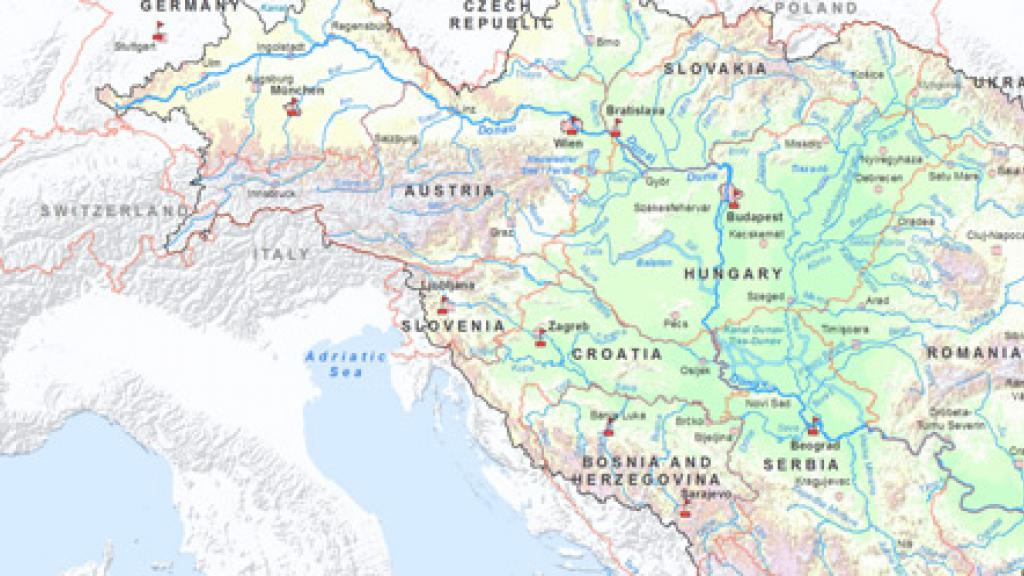
Maps of the Danube River Basin District Management Plan 2015
The following maps have been produced for the Danube River Basin Management Plan Update 2015. The individual map files have a higher resolution.
Downloads
-
DRBM Plan Update 2015 - Maps (37.73 MB)
Complete set of thematic maps supplementing the Danube River Basin District Management Plan - Update 2015. -
Map 1: DRBD Overview (2.1 MB)
-
Map 2: Ecoregions (1.55 MB)
-
Map 3: Deliniated Surface Water Bodies (1.62 MB)
-
Map 4: Transboundary Groundwater Bodies of Basin-Wide Importance (1.85 MB)
-
Map 5: Urban Wastewater Treatment – Reference Situation 2011/2012 (2.59 MB)
-
Map 6: Main Industrial Facilities – Reference Situation 2011/2012 (1.63 MB)
-
Map 7a: Nutrient Pollution from Point and Diffuse Sources – References Situation: Nitrogen 2009–2012 (1.64 MB)
-
Map 7b: Nutrient Pollution from Rural Sources – References Situation: Nitrogen 2009–2012 (1.6 MB)
-
Map 7c: Nutrient Pollution from Urban Sources – References Situation: Nitrogen 2009–2012 (1.65 MB)
-
Map 8a: Nutrient Pollution from Point and Diffuse Sources – Reference Situation: Phosphorus 2009–2012 (1.67 MB)
-
Map 8b: Nutrient Pollution from Rural Sources – Reference Situation: Phosphorus 2009–2012 (1.65 MB)
-
Map 8c: Nutrient Pollution from Urban Sources – References Situation: Phosphorus 2009–2012 (1.65 MB)
-
Map 9: Alteration of River Continuity for Fish Migration – Current Situation 2015 (1.68 MB)
-
Map 10: Alteration of River Morphology – Current Situation 2015 (1.58 MB)
-
Map 11: Wetlands / Floodplains (>500 ha) with Reconnection Potential (1.61 MB)
-
Map 12: Hydrological Alterations – Impoundments: Current Situation 2015 (1.66 MB)
-
Map 13: Hydrological Alterations – Water Abstractions: Current Situation 2015 (1.61 MB)
-
Map 14: Hydrological Alterations – Hydropeaking: Current Situation 2015 (1.63 MB)
-
Map 15: Future Infrastructure Projects (1.61 MB)
-
Map 16: Site-specific Biological Contamination (SBC) Index of Invasive Alien Species on JDS3 Sites: Macroinvertebrates (1.63 MB)
-
Map 17: Site-specific Biological Contamination (SBC) Index of Invasive Alien Species on JDS3 Sites: Fish (1.63 MB)
-
Map 18: Water-related Protected Areas (>500 ha) (6.08 MB)
-
Map 19: Transnational Monitoring Network – Surface Waters (1.63 MB)
-
Map 20: Heavily Modified and Artificial Surface Water Bodies (1.58 MB)
-
Map 21: Ecological Status and Ecological Potential of Surface Water Bodies (1.6 MB)
-
Map 22a: Chemical Status of Surface Water Bodies (priority substances in water) (1.65 MB)
-
Map 22b: Chemical Status of Surface Water Bodies (mercury in biota) (1.48 MB)
-
Map 23: Quantitative Status of Groundwater Bodies of Basin-wide Importance (1.66 MB)
-
Map 24: Chemical Status of Groundwater Bodies of Basin-wide Importance (1.66 MB)
-
Map 25: Exemptions According to EU WFD Articles 4(4) and 4(5) – Surface Waters (1.5 MB)
-
Map 26: Exemptions According to EU WFD Articles 4(4) and 4(5) – Groundwater (1.79 MB)
-
Map 27: Hydropower Plants – Reference Situation 2012 (1.74 MB)
-
Map 28: Status of Urban Wastewater Treatment – Baseline Scenario 2021 (2.58 MB)
-
Map 29: Status of Urban Wastewater Treatment – Midterm Scenario (2.58 MB)
-
Map 30: Status of Urban Wastewater Treatment – Vision Scenario (2.58 MB)
-
Map 31: Nitrates Vulnerable Zones – Reference Situation 2012 (1.68 MB)
-
Map 32a: Nutrient Pollution from Point and Diffuse Sources – Baseline Scenario 2021: Nitrogen (1.62 MB)
-
Map 32b: Nutrient Pollution from Rural Sources – Baseline Scenario 2021: Nitrogen (1.59 MB)
-
Map 32c: Nutrient Pollution from Urban Sources – Baseline Scenario 2021: Nitrogen (1.65 MB)
-
Map 33a: Nutrient Pollution from Point and Diffuse Sources – Baseline Scenario 2021: Phosphorus (1.69 MB)
-
Map 33b: Nutrient Pollution from Rural Sources – Baseline Scenario 2021: Phosphorus (1.62 MB)
-
Map 33c: Nutrient Pollution from Urban Sources – Baseline Scenario 2021: Phosphorus (1.65 MB)
-
Map 34: Alteration of River Continuity for Fish Migration – Expected Improvements by 2021 (2.04 MB)
-
Map 35: Ecological Prioritisation Regarding Restoration Measures for River and Habitat Continuity (1.82 MB)
-
Map 36: Alteration of River Morphology – Expected Improvements by 2021 (1.56 MB)
-
Map 37: Hydrological Alterations – Expected Improvements by 2021 (1.67 MB)
Related
-
Vienna, 16 December 2015. Defining the water management priorities for the Danube Basin until 2021, the ICPDR has published the Danube River Basin Management Plan Update 2015 and the Flood Risk Management Plan for the Danube River Basin today.