Danube Watch 3/2021 - WACOM: Water Contingency Management in the Sava River Basin

WACOM: Water Contingency Management in the Sava River Basin
By Primož Banovec, PhD, (University of Ljubljana), Robert Mikac, PhD (AZUR), Samo Grošelj (ISRBC)
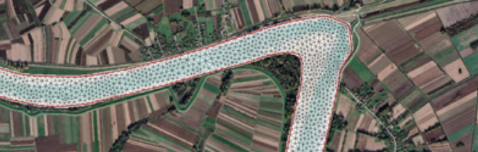
Figure 1: An example of a model mesh with the underlying terrain grid
Introduction
The risk of accidental pollution and floods is one of the major challenges in all transboundary river basins. The recent major accidental pollution in the Sava River Basin, which occurred on the Spreča River (BA-2018) and the Rižana River (SI-2019) including the worst floods in May 2014, showed that the system of coping with such events must be advanced with stronger cooperation between varying sectors, such as water management, civil protection, navigation, and hydropower. They triggered the implementation of the Water Contingency Management in the Sava River Basin (WACOM) project.
The lead partner is the University of Ljubljana (SI), while the other partners are water management institutions such as the Slovenian Water Agency (SI) and Croatian Waters (HR), hydropower company HESS (SI), the Ministry of the Sea, Transport, and Infrastructure (HR), along with national authorities for navigation. In addition, the civil protection sector is covered by the Association for Risk Management (AZUR) and Civil Protection Administration of the Republic of Srpska (BA). The other partners are the Jaroslav Černi Institute (RS) and the Sava Commission.
The project commenced in July 2020, is due to finish in December 2022, and is co-funded by European Union funds (EDRF, IPA).
Main and specific objectives of the WACOM project
The project’s main objective is to reduce environmental risks related to accidental pollution and floods. More specifically however, additional objectives are to ensure:
- Improved transnational procedures for response to accidental pollutions and floods;
- Improved transnational cooperation;
- More efficient joint response in the case of accidental pollution/flood emergencies.
The project strives to strengthen the transnational and trans-sectorial cooperation among institutions, responsible for water and flood management and civil protection in the phases of preparedness and response.
Implementation
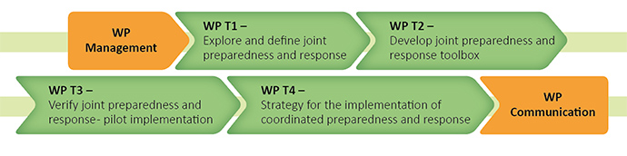
The project is divided in six work packages as shown in the figure below:
Legal Background
Recognizing the vital importance of transboundary cooperation, the Parties to the Framework Agreement on the Sava River Basin (FASRB), should undertake measures to prevent or limit hazards and reduce and eliminate adverse consequences of floods and incidents involving substances in the water. The Parties are obliged to establish a coordinated or joint system of measures, activities, warnings, and alarms for extraordinary impacts on the water regime.
In implementing the FASRB, the Parties have already concluded four protocols: Protocol on Navigation regime, Protocol on Prevention of Water Pollution Caused by Navigation, Protocol on Flood Protection and Protocol on Sediment Management. Meanwhile, the Protocol on Emergency Situations is foreseen to be harmonized soon. Three of them formulate the basis for the implementation of the WACOM Project.
The process of mapping institutions, procedures and activities was completed in the first half of 2021 and carried out within three areas – civil protection, water management and river navigation, and at different levels (strategic, tactical, and operational) with a particular interest in current legislative procedures. However, the entire mapping process was also conducted and finished under extreme circumstances during the COVID-19 pandemic, with lockdowns in effect in all participating countries for most of the time. It was essential to strive to meet multiple functions in order to follow the initial project assumptions/settings and examine the current situation. This also served as a gap analysis to identify specific areas where it was necessary to change and/or create new procedures. Four national workshops and three regional workshops were held in spring and autumn 2021 within this activity. The project is divided in six work packages as shown in the figure below:
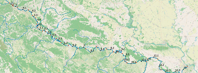
Figure 2: The extent of the modelling area and modelling sections
| Model | Model section |
|---|---|
| 1 | from Čatež to confluence with Sutla |
| 2 | from confluence with Sutla to confluence with Bregana |
| 3 | from confluence with Bregana to confluence with Krapina |
| 4.1 | from confluence with Krapina to highway bridge at Ivanja Reka |
| 4.2 | from bridge at Ivanja Reka to ferry line between Oborovo and Vrbovo |
| 4.3 | from ferry line between Oborovo and Vrbovo to ferry line Martinska Ves |
| 4.4 | from ferry line Marinska Ves to ferry line Tišina |
| 4.5 | from ferry line at Tišina to confluence with Kupa |
| 5.1 | from confluence with Kupa to ferry line Gradusa Posavska |
| 5.2 | from ferry line Gradusa Posavska to ferry line Selišće Sunjsko |
| 5.3 | from ferry line Selišće Sunjsko to Lonsko polje |
| 5.4 | from Lonsko polje to confluence with Una |
| 6.1 | from confluence with Una to Orahova |
| 6.2 | from Orahova to Gradiška |
| 6.3 | from Gradiška to confluence with Vrbas |
| 7 | from confluence with Vrbas to confluence with Orljava |
| 8.1 | from confluence with Orljava to Brod |
| 8.2 | from Brod to Donji Svilaj |
| 8.3 | from Donji Svilaj to confluence with Bosna |
| 9.1 | from confluence with Bosna to Domaljevac |
| 9.2 | from Domaljevac to Orašje |
| 9.3 | from Orašje to confluence with Tinja |
| 10.1 | from confluence with Tinja to Brčko |
| 10.2 | from Brčko to ferry line at Jamena |
| 10.3 | from ferry line at Jamena to confluence with Drina |
| 11 | from confluence with Drina to confluence with Bosut |
| 12.1 | from confluence with Bosut to Sremska Mitrovica |
| 12.2 | from Sremska Mitrovica to Šabac |
| 12.3 | from Šabac to TPP Nikola Tesla |
| 12.4 | from TPP Nikola Tesla to confluence with Kolubara |
| 13 | from confluence with Kolubara to Beograd |
In the framework of the WACOM project a rapid joint preparedness and response toolbox will be created in line with the operational family of tools developed and used by the ISRBCL: the GeoInformation System for the Sava River Basin (Sava GIS), Hydrological Information System of the Sava River Basin (Sava HIS) and Flood Forecasting and Warning System in the Sava River Basin (Sava FFWS). The modelling module is based on the two-dimensional (2D) hydraulic and oil spill propagation modelling, with the oil spill modelling based on the precalculated hydraulics of the river sections. The extent of the modelling area and modelling sections are shown in figure 2.
The 2D hydraulic models are based on a flexible mesh system to provide an adequate level of resolution, thus allowing model simulations to be performed on a reasonable timescale. An example of the computational mesh is presented in figure 1.
All the same the specific challenge is identification of a suitable framework for exchanging information and coordinating the plethora of identified institutions in the transnational context. For example, three out of four Sava countries follow the USA’s example – National Incident Management System (NIMS), and its specific component, the Incident Command System (ICS) – in incident management processes. For that reason, the ICS was found suitable for the definition of the key transnational emergency processes, certainly with several adaptations necessary.
The toolbox will be verified at table-top exercises in May 2022 providing a unique opportunity for stakeholders involved in disaster rescue, protection, and rehabilitation, to learn, improve their skills and competences and form cross-sectoral links. The main purpose of exercises is to increase effectiveness in their rescuing, protection, and rehabilitation activities when disaster occurs.
The project will finish in December 2022, and the final public event will be organized at the end of November, tentatively. The basic aim of this event is that the public will be informed on the main project outputs and results – in any case it is expected that the stakeholders will recognize the potential of these exercises.
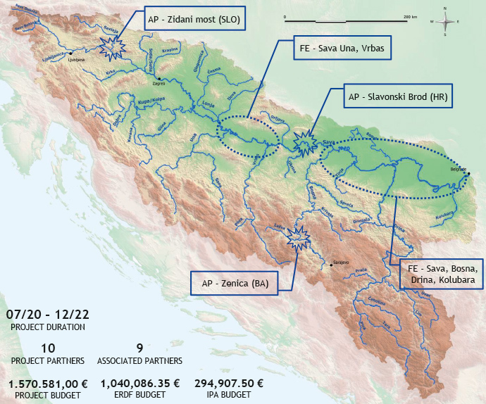
Figure 3: Locations of the emergency events at Zidani most (SI), Slavonski Brod (HR) and Zenica (BA).